Thursday, October 8, 2009

Neighborly Hospitality: Adirondack Style

Thursday October 8, 2009: "Travel"........... Is said to be the best educator of all, and I tend to agree with those words. Isn't it funny though how we sometimes don't realize just how much we'll learn from a journey until we're actually back home and the trip is over? Take neighborly hospitality for example. If there's anything I've learned on this trip, its how some northerly neighbors will unselfishly take it upon themselves to look after you during your time of greatest need.

You know, like them taking time from a busy schedule to ensure you return home from a long arduous journey to a freshly vacuumed floor and a well stocked refrigerator. Believe me; it just makes my heart as soft as.............well..........marshmallows.

Problem is, how do you ever repay a friend like that? Well, I suppose I could start by cleaning up his yard of debris and putting it in a nice out of the way place. That way, when they come home they don't have to deal with yard work.


I could mail gifts to show my appreciation and being handy with tools, maybe I could even do some "fix-it-up" things that look to need attention. You know, stuff that looks broken or in obvious need of repair.  Like say...... a mailbox that needs remounting or something easy to do, yet extremely helpful.    hee hee.


Naturally, it's always a great idea to use tamper-proof screws when securing something valuable in place. You know, the type with special head designs that require a specific tool that most homeowners, thieves and would-be wrongdoers don't have. That's it, nice and secure so the box can't be stolen or easily removed.

I'm even thinking of giving them a cookout, Adirondack style. You know, with plenty of marshmallows and a nice high vantage point for optimal viewing of the fall foliage. Yeah, that might be appropriate considering it's the giving season. I'm starting to feel better already and the stresses of the trip are but a fading memory. Amazing how a mental redirect can change an attitude isn't it?


I'm finding there's a lot of truth in the old adage that "there's more pleasure in giving, than receiving". It's all about give and take as well as attitude. If life gives you lemons..........make lemonade. If your friends bring the franks and marshmallows, then by golly, it's your responsibility to provide the roastin'.     Just doin' my part to be neighborly ye know.  hee hee.....

Sunday, October 4, 2009

Go, Stay, or Return to Michigan


View Larger Map

Sunday October 4, 2009: Stuck here in Antigonish, Nova Scotia in a campground about 35 miles west of Cape Breton Island and the Cabot Trail. Pouring rain all day and I'm doing laundry. Received news of Jerry's death and I'm waiting for funeral details before deciding whether to continue on or abort and return to Jackson. Whether or not I could even make the 1,600 miles home in time will depend on the funeral schedule. Turning back would be dissappointing, but with continued rain forecast for three of the next four days, it wouldn't be that difficult since I'm not getting the weather to enjoy the Cabot Trail or take the photographs I came for in the first place.  Time will tell.

Tidal Bores and the Shubenacadie River


Shubenacadie River and the Tidal Bores: Being the host of the world’s highest tides, the Bay of Fundy also delivers the most exhilarating way to take in this natural wonder. The great Shubenacadie River empties into the Cobequid Bay of the Bay of Fundy, and is one of only about seven places in the world where you can experience the thrill and exhilaration of tidal bore rafting! With tidal bores that can reach up to 10’ in height, you’ll have an experience you are not likely to forget.

The tidal bore is a tidal phenomenon in which the leading edge of the incoming tide forms a wave (or waves) of water that travel up a river or against the direction of the current.   This happens twice a day as a result of the incoming tide and guides will take you for an adventurous white water rafting adventure upstream.  

While the timing of my arrival (and approaching nightfall) prevented me from actually witnessing a tidal bore event, I did learn a lot from the Interpretive Center and talking with people who have participated in rafting it.  Apparently, there are but 11 places on the planet where this phenomenon occurs with only 5 of those in North America.  

Bores usually occur in areas with a large tidal range such as the Bay of Fundy, and where incoming tides are funneled into a shallow, narrowing river via a broad bay. The funnel-like shape not only increases the height of the tide, but it can also decrease the duration of the flowing tide down to a point where the flood appears as a sudden increase in the water level.  For more information on visit: http://www.tidalboreraftingpark.com/gallery.php

The Bay of Fundy Coastline


View Larger Map

Saturday October 3, 2009:  Weather last night allowed camping for the first time on this trip.  Fortunately, I was able to make it to the Cape Split / Scots Bay area just in time to sit up camp on a small cliff overlooking the bay.  Since I had printed off the tidal charts to bring with me, I already knew I was arriving almost exactly at peak low tide.  Careful where you sent up camp because the Bay of Fundy has the highest tidal changes of anywhere in the world!  While most of us have witnessed a normal 3-4' tidal change at the beach, the geographical layout of the bay causes extreme tidal shifts in the 41-48' range between low and high tide. 


Scotts Bay Pier: Fishing boats, on the Bay of Fundy,  have to schedule their departure and arrival into home port with the tide as most harbors don't have any water during low tide.  Boat owners have to prop the boats up to prevent them from falling over when the harbors dry out and the boat ends up sitting on the somewhat dry ocean floor.  The picture above, taken at Scotts Bay pier, shows lobster pots waiting for high tide to allow the boat in/out of port. 

The Lady Chantel: The picture below, taken on the backside of the same pier, shows the "Lady Chantel" sitting on the harbor floor during low tide.  Here she'll sit for another 5-6 hours until the arrival of the next high tide which will occur around 1:00am on this particular day.  The boats owner brings her along the mainland side of the pier and secures her during high tide to allow the boat to settle to the soft sandy bottom instead of the unforgiving rocks on the seaward side. 


Burncoat Head:  (B) on the map above.  Home of the highest recorded tidal change in the world.  So here I was on the Bay of Fundy, minding my own business, when I realized that normal people don't get to see 100 billion tonnes of seawater flowing back and forth in front of their kitchen windows every day. As someone who didn't grow up on a coastline, it's almost unfathonable for me to imagine how much water that is.  Let me say it again; "100 billion tonnes of water" flow in and out of the Bay of Fundy during each tidal cycle and that occurs twice daily!  How much is 100 billion tonnes of water you ask?  It's more than the combined flow of all the world's freshwater rivers! 

To help illustrate, take a look at the island at Burncoat Head pictured above. This is what it looked like upon my arrival around 12:30pm.  The picture below, taken only a couple of hours later, starts to give you an idea of the volulme of water that moves in and out. Keep in mind that a full tidal change takes approximately 6 hours and 15 minutes.  Unfortunately, I had not the time to wait for low tide, but given the amount of water moving in just a couple hours, I can only imagine the view after another four hours of receding water.


Visitors can see two extraordinary high and low tides every 24 hours. As such, you can reasonably expect to see at least one high and one low tide during daylight hours. Tide times move ahead approximately one hour each day, and tide times vary slightly for different locations around the Bay.


Again, keep in mind these pictures represent only about two hours worth of tidal change versus the the complete.  Maybe I can get the time to capture the full effect later on my way back.

Twice everyday the Bay fills and empties of its 100 billion tonnes of water, creating the highest tides in the world. The height of the tide is about (11ft) along the southwest shore of Nova Scotia and steadily increases as the floodwaters travel up the 174 miles of shoreline to the head of the Bay where in the Minas Basin the height of the tide can reach 53 feet.

The Princess of Acadia and Western Shores of Nova Scotia


Friday October 2, 2009:  The storms continue to haunt me all the way to the Saint John's ferry terminal so not a lot of pictures to share.   The three hour passage to Digby, Nova Scotia was aboard the MV Princess of Acadia.  A bow and stern loader built here in the Saint John shipyards in 1971, she is 480' long, 67' wide and has a normal draft of approximately 15 feet.  With a gross tonnage capacity of 10050 tons she's capable of carrying 240 tons of fuel oil, 164 tons of fresh water, 650 passengers, 155 automobiles, 33 tractor trailer units and/or (1) yellow BMW motorcycle on two large cargo decks. Bikes always board first and the crew was extremely friendly and helpful at getting the bike secured to the floor anchors with rachet straps which they provide.


Not until we're away from New Brunswich and in the middle of the Bay of Fundy do we leave the omenous skies behind and are greeted with much welcomed sunshine.  Been so long since I had witnessed any, I had to ask what the blue stuff was.  The passage takes three hours and covers 39 nautical miles to the port at Digby, Nova Scotia.  The ship is well equipped with a cafeteria, business lounge with free wireless, seating lounges, bar lounges, arcade, newstand, etc.  The ferry ride saves 7 hours and 362 miles of driving.  With the rain being what it was, I needed the break from rainy riding to just relax and enjoy the scenery for a change.

View Larger Map

An Acadian Welcome

October 01, 2009: For me, Fall is the one of the most anticipated seasons of the year. Having never visited the New England states, it seemed reasonable to time it with the peak in fall colors. It's true that the weather can change rapidly and it becomes increasingly cooler especially at night and in the early morning. Water temperatures are falling precipitously, daylight hours are shrinking rapidly, and the curtains have closed on most campgrounds and many motels, especially in the remote areas which I prefer to visit.  This is playing out to be a significant factor which I had not anticipated well enough.  What this has meant is a lot more nights in motels, and lot less photographic opportunities than I would like.

                              
October 01, 2009:  Since the weather has been so bad, I decided to forego Acadia National Park and the Bar Harbor area in hopes of better weather coming back and besides, peak foliage is still a week or two away in this region.  So, a quick visit to the local police station in Ellsworth, Maine to check my weapon for passage into Canada and I high-tailed it up the coast in an effort to outrun the storm.  Fat chance of that.....haaaaaaaaaaa.     

I traveled up state Hwy 189 in the Northeastern most corner of the United States through Lubec, Maine, across the bridge onto Campobello Island with intentions to ferry across Passamaquoddy Bay to mainland New Brunswich.  From there, I was to make my way to St. Johns and ferry across to Nova Scotia.  As luck would have it, I hadn't checked the ferry schedule well enough and arrived to find it had closed for the season a day earlier.  So, I backtrack into the storm in seek of an alternative northern route and 60 miles later, cross into Canada at Calais Maine.

Wednesday, September 30, 2009

Quintessential Vermont and New England


Pietree Orchard: Rolling down Waterford Road near Sweden, Maine you'll happen upon Pietree Orchard.  High atop a hill overlooking the surrounding landscape is this perfectly manicured orchard of organically and conventionally grown apples.  Matter of fact, just about every apple the mouth could savor; Red Astrican, Lodi, Vista Belle, Jersey Mac, Paula Red, Virginia Crab, Machintosh, Red & Golden Delicious, Mutsu, Northern Spy, Rome, Winesap and plethera of others that I'm unfamiliar with.  I call em' all "good" apples.  On a side note, the orchard is owned by Tabitha King, wife of the author Stephen King.  Apparently, they have a home in the area and he spends some of his time here while his wife manages the orchard and small store.  If you're in the area at apple time, it's a must see. 
For more information, you can visit their site http://www.pietreeorchard.com/

Sayre's Bridge in Thetford, Vermont


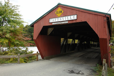
Thetford, Vermont is home to the 134 feet long Sayre's Bridge.  Located only about 1/4 mile outside Thetford on Tucker Hill Road, the bridge was built in 1839 to provide local families a means to cross the Ompompanoosuc River.  It was constructed as a single span using what has been called a "Haupt Truss" with arch support design.  Not until 1963 was a mid-stream support added.  Recently the bridge underwent a major five month, $814,000 rehabilitation and was officially reopened to traffic on October 10, 2007.  

The waterpower provided by the river in this location once served eight sawmills, four gristmills, a straw-board and paper mill, two flannel factories, a carriage shop and bedstead factory, an edge tool and trip-hammer works, and the Sayre Brothers furniture mill.


While I'm there, a local stops to talk and shares a bit of history regarding the bridge.  Apparently, a few short years ago, a lady and her two small children were crossing in the dead of winter with lots of ice and snow buildup on the floor of the bridge.  If you'll notice on the previous post, many bridges were constucted with extra timbers on the floor to provide raised parallel "tracks" for vehicles to roll on.  I can only assume this was to create a wear surface which was easily replaceble instead of having to re-floor the entire bridge as the surfaces wore down under vehicular traffic. 

According to story, the lady was crossing when ice buildup on the raised panels caused her car to slide off violently enough to crash through the bridge, and plummet into the icy waters below. Fortunately for her and the children, a local fireman was approaching the bridge at the same time and was able to rescue all three from a certain disaster.  Secondary to the incident, the town counsel voted to reconstruct the floor without the raised panels and thus the reason for it's current flooring configuration.  Seeing how strongly these structures are built inside, it's difficult for me to imagine crashing completely through the side of one but...........that's what the gentleman says happened and he seemed to know what he was talking about.  I just love learning these little tid-bits from the locals.

Fall Has Hit New England


Wednesday Sept. 30, 2009: Tonight, I'm in Ellsworth, Maine.  Today consisted of 258 miles of what would have been the most beautiful colors had it not been for an all-day pouring rain.  Fall has definately hit the New England states, but unfortunately, so has the rain, by the bucketfuls.  At last count, I think I've seen approximately 3-4 hours of sunshine since Saturday morning.  Needless to say, my efforts at photography have been very limited.  I just can't seem to get the colors captured with the dark overcast skies and the almost constant rain.  During the few periods of sunlight, I did manage to capture a couple shots to share.  Maybe it'll be better on the return side.

I find myself very intrigued by the engineering of the support trusses that support these covered bridges.  Keeping in mind they were built at a time before steel "I" beams were common to bridge construction, the spans are commonly well over 100 feet.  The longest being the Blenheim Bridge in New York which is 228 feet long with an incredible 210' feet between abutment supports.  With support truss names like  the Burr, Inverted Bowstring, Multiple King, Paddleford Arch, Tied Arch, Town and Supplement, etc., it's going to be interesting to learn more about the construction techniques of the period and why one design was favored over another.  More on that later if I'm fortunate enough to visit them coming back.

Vermont along has something like 100+ covered bridges and I had intended to visit approximately 25-30 of them.  Unfortunately, the weather isn't cooperating, but I was able to visit about four before aborting the bridge tour for now.  Just as a reminder, you can click on each picture for a full screen view.


Tuesday, September 29, 2009

Big Bikes and Pumpkin Chunkin


Monday Sept. 28, 2009: While I'd love to share wonderful pictures of the Adirondacks Mountains in Northeastern New York, three days of rain is playing havoc with my photographic efforts.  Despite some bad weather luck, I still managed to grab a picture or two of some interesting things along the way.  This bigger than life chopper complete with "ape hanger bars" was especially build for somebody like Doug........haaaaaaaaa

"Pumpkin Chunkin"  Steady rain for most of three days now has prevented me from taking a lot of pictures but I was able to stumble upon something interesting in the New York countryside. Somewhere on a lonely road in the middle of nowhere, I came upon the Glosser family farm and their trusty John Deere green "Pumpkin Chunker".  A device custom build for the sole purpose of sending 10"-12" pumpkins great distances using a large volume of compressed air.  How far you ask?
Funny, I had the same question.  When the operator informs me he could send it over the line of trees in the distance, I'm thinking to myself.........."no freakin way mate, that treeline is at least a 1/4 mile away.  With a sly grin the Glossers were happy to demonstrate.


They tell me their longest measured shot to date is 3,200 feet!!!!  To put that into prospective, a mile is only 5,280 feet.  Now that's what I'd call a "Punkin Chunker"  These guys also tell me that the record holders have cannons at least 3-4 times as large as this one, some with barrels as long as 100 feet.  Apparently those monsters are approaching shots of a mile long.  Pumpkin Pie anyone? For more information, go to http://www.punkinchunkin.com/

Monday, September 28, 2009

Genesee River Gorge


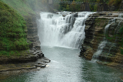
Sunday Sept 27, 2009:  Located just 35 miles south of Rochester, New York, I discovered the magnificence of Letchworth State Park and the plush Genesee River Gorge.  The plunge and spray of three dramatic waterfalls, and the lush forest all contribute to make this what must be one of the most beautiful valleys in the state.  The highest fall is currently 107 feet but every year the river cuts deeper into the limestonea and shale cliffs which approach 600 feet in height.


It's not even difficult to find a great place to........well..........just sit and enjoy the scenic beauty of the valley.

Who Left the Water Running?


Saturday Sept. 26, 2009:  Honey, is that the toilet I hear running?  You'd think a good Texas-sized plumber could have gotten that leak under control by now.  Big Tom, where are you?
Niagara Falls turned out to be even more spectacular than I had imagined.  I knew it would be big, but it's impressive to say the least.   For those who have never visited, the falls are actually divided into an American and a Canadian side, divided into three very distinct falls by Goat and Luna Islands. 

Accessible by bridge, Goat Island is perfectly situated between the two countries and offers a most beautiful vantage point known as Tarrapin Point.  The Canadian Horseshoe falls, pictured above from Tarrapin point, is considerably larger and makes up approximately 90% of the total water flowing over Niagara.  With a cresline of 2,500 feet, the horseshoe falls plunges 167 ft. to the river below dumping an amazing 675,000 gallons of water per second.


American Side: A view of the American side from Luna Island, a small off-shoot from Goat Island accessible only by footbridge.  With a crestline of 1,100 feet, the water spills approximately 75,000 gallons per second 176 ft. to the waiting river below.  From there, it flows into Lake Ontario and eventually the Atlantic Ocean by way of the St. Lawrence Seaway.


Walkway to Cave of the Winds:  A trip to Cave of the Winds allows access to a view of the American Falls from the river level below and is well worth the time spent.  Only from below can you see and feel first hand the legendary force of nature.


Hurricane Deck: A trip up to the "Hurricane Deck" is............well..................exactly as you would imagine.  Frankly, I don't know why we even bother with the yellow ponchos.  You're going to get soaked, but the experience is one you'll not soon forget.